582 Main Street · Chatham, MA 02633
·
(508) 945-6450
KAHN FINE ANTIQUES
Fine Antiques & Works of Art
Search
Home
Collections
▼
All Recently Sold Antiques and Works of Art
Antique Bookends
Antique Boxes, Nantucket Baskets, Books
Antique Clocks, Barometers, Sextants, and Telescopes
Antique Firearms, Swords, and Militaria
Antique Furniture, Folk Art, and Needlework
Antique Paintings, Maps, Documents, Photos
Antique Porcelain, Antique Glass, and Canes
Antique Presidential Items
Antique Scrimshaw and Whaling Items
Nautical Antiques and Antique Ship Models
New Collector's Antiques for Under $300
Newest Antique Acquisitions
Silver, Brass, Lamps, Jewelry and Metalware
Inquiries
Search
(508) 945-6450
info@kahnfineantiques.com
Search & Filter
×
Search
Collection
All Categories
All Recently Sold Antiques and Works of Art
Antique Bookends
Antique Boxes, Nantucket Baskets, Books
Antique Clocks, Barometers, Sextants, and Telescopes
Antique Firearms, Swords, and Militaria
Antique Furniture, Folk Art, and Needlework
Antique Paintings, Maps, Documents, Photos
Antique Porcelain, Antique Glass, and Canes
Antique Presidential Items
Antique Scrimshaw and Whaling Items
Nautical Antiques and Antique Ship Models
New Collector's Antiques for Under $300
Newest Antique Acquisitions
Silver, Brass, Lamps, Jewelry and Metalware
Min Price ($)
Max Price ($)
Sort By
Featured First
Price: Low to High
Price: High to Low
Name A–Z
Sold Only
REFINE
Home
›
All Recently Sold Antiques and Works of Art
/
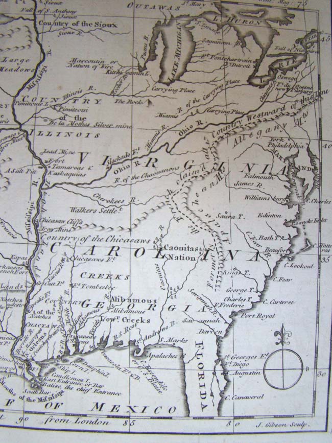
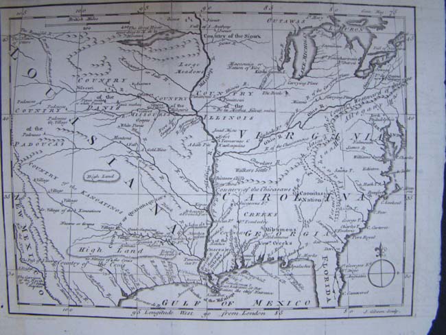
An 18th century Map showing the Louisiana Territory, The Carolinas, Virginia and the Great Lakes region circa 1763.
🏺
IMAGE COMING SOON
SOLD
CLICK TO ENLARGE
VIEW ALL
2
Antique Paintings, Maps, Documents, Photos
An 18th century Map showing the Louisiana Territory, The Carolinas, Virginia and the Great Lakes region circa 1763.
SOLD
Engraved by J. Gibson circa 1763. Unframed measuring 10 1/2" by 8".
Category
Antique Paintings, Maps, Documents, Photos
Item No.
KFA-0807
INQUIRE ABOUT SIMILAR PIECES
← BACK
SHARE
EMAIL
FACEBOOK
From the Same Collection
Related
Items
Antique Paintings, Maps, Documents, Photos
“Sunrise over Nantucket, 1835“, a limited-edition lithograph by JOHH STOBART dated 1987
$
1,499
Antique Paintings, Maps, Documents, Photos
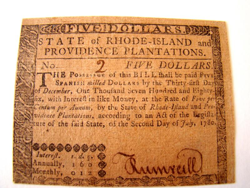
A RARE State of Rhode Island $5.00 note issued July 2, 1780, serial No.2
$
1,599
Antique Paintings, Maps, Documents, Photos
A Map of the Western States of the United States published in 1887
$
225
Antique Paintings, Maps, Documents, Photos
A fine original oil on canvas entitled "Floral Pathway" circa 1916 by Anna Lillian Winegar (1867-1941)
$
2,595
$
1,595
‹
×
›
⇧